How to Identify Location from Photo Online Free

You've got a photo. Maybe somebody sent it to you. Maybe you saved it from somewhere and can't remember the source. Maybe it's an old picture from a phone you no longer own. One question: where was this taken?
The good news is you can identify location from photo online free — no paid subscriptions, no credit cards, no software downloads. The catch is that most "free" tools you'll find are either crippled versions of paid products or only work on a narrow set of images. I've spent months testing every method I could find, and four approaches consistently deliver without asking for money. Let me walk through them in the order you should try them.
Method 1: Check for hidden GPS data (instant, but often empty)
Every photo taken on a modern smartphone carries invisible metadata called EXIF. If location services were enabled when the photo was captured, that metadata includes exact GPS coordinates — latitude, longitude, sometimes even altitude and heading.
This is the fastest way to find photo location. The problem? It rarely works on photos that didn't come straight from your own camera.
Here's when EXIF data survives and when it doesn't:
| Source | EXIF GPS intact? | Why |
|---|---|---|
| Photo from your camera roll | Usually yes | Camera writes GPS directly |
| Photo sent via email | Sometimes | Depends on email client settings |
| Photo from WhatsApp/Telegram | No | Messaging apps strip metadata |
| Photo from Instagram/Facebook/X | No | All social platforms remove it |
| Screenshot | No | Screenshots create a new file with no metadata |
| Photo from a website | Rarely | Most CMS platforms strip EXIF on upload |
How to check, free and fast
You don't need to install anything. Three options that work right now in your browser:
On Mac: Right-click the image → Open With → Preview → Tools → Show Inspector → GPS tab. If there's a map, you're done.
On Windows: Right-click → Properties → Details tab. Scroll down to GPS section.
Online tools: Jeffrey's Image Metadata Viewer (exif.regex.info) or exifdata.com — both free, both upload your file to their server though. If privacy matters, stick with the local method above.
For a deeper dive on what your photos reveal and how to protect yourself, our EXIF metadata guide covers the full picture.
When EXIF comes back empty — and for photos from the internet, it usually does — move on to the next method.
Method 2: Reverse image search (free, good for landmarks)
Reverse image search takes your photo and compares it against billions of images already indexed on the web. If someone else has posted a similar picture — maybe with a caption or location tag — you might find your answer.
This method is completely free and works well for famous places. The Eiffel Tower, Times Square, the Colosseum — these are photographed millions of times, so a match is almost guaranteed. The engine finds visually similar images, and you trace the location from whatever caption or context those images carry.
Where it falls apart: photos that haven't been posted online before. A random street corner in a small town? A beach with no landmarks? Reverse search will return nothing useful.
Three engines worth using
Google Lens — The biggest index, best for Western landmarks and widely-photographed locations. Available at lens.google.com, also built into Google Photos and the Google app.
Yandex Images — Don't skip this one. Yandex consistently catches locations that Google misses, especially across Eastern Europe, Russia, Central Asia, and parts of Southeast Asia. The interface is in Russian, but your browser's translate function handles that. I've seen Yandex nail a location that Google, TinEye, and Bing all failed on — a residential street in Tashkent that none of them could place.
TinEye — The oldest reverse search engine. Rather than finding similar images, TinEye looks for exact copies of your photo across the web. Useful if you're trying to trace where an image originally came from, less useful for finding the geographic location of a unique photo.
Pro tip: Run your photo through at least two engines. Each one has different coverage, and combining results dramatically improves your hit rate.
For the full breakdown of how reverse search compares to AI-based methods, our reverse image search vs AI geolocation analysis goes deep on the differences.
Method 3: AI geolocation (free, works on almost anything)
This is the method most people don't know about yet, and it's the one that handles the widest range of photos. Instead of looking for a copy of your image online, AI geolocation reads the actual visual content — buildings, vegetation, road markings, signage, terrain, shadows — and predicts where in the world that scene sits.
No GPS needed. No internet posting history required. A screenshot, a scanned old print, a photo you took yourself — the AI reads the picture and gives you its best guess in seconds.
Why this works where other methods fail
Think about what makes a place recognizable. The architecture tells you about climate and culture. Flat roofs suggest low-rainfall regions. Steep pitched roofs mean snow country. The script on signs narrows things down fast — Cyrillic wipes out most of the planet, Arabic script narrows further, Hangul tells you South Korea. Even the design of utility poles, the color of soil, and the species of trees all carry geographic fingerprints.
An AI model trained on millions of geotagged photos has seen these patterns countless times. When you upload a photo, it weighs all these signals simultaneously and produces a location prediction with a confidence score.
How to use it — step by step
- Open GeoSpy in any browser (desktop or mobile)
- Click upload or drag your photo into the window
- Wait 5-10 seconds while the AI analyzes the image
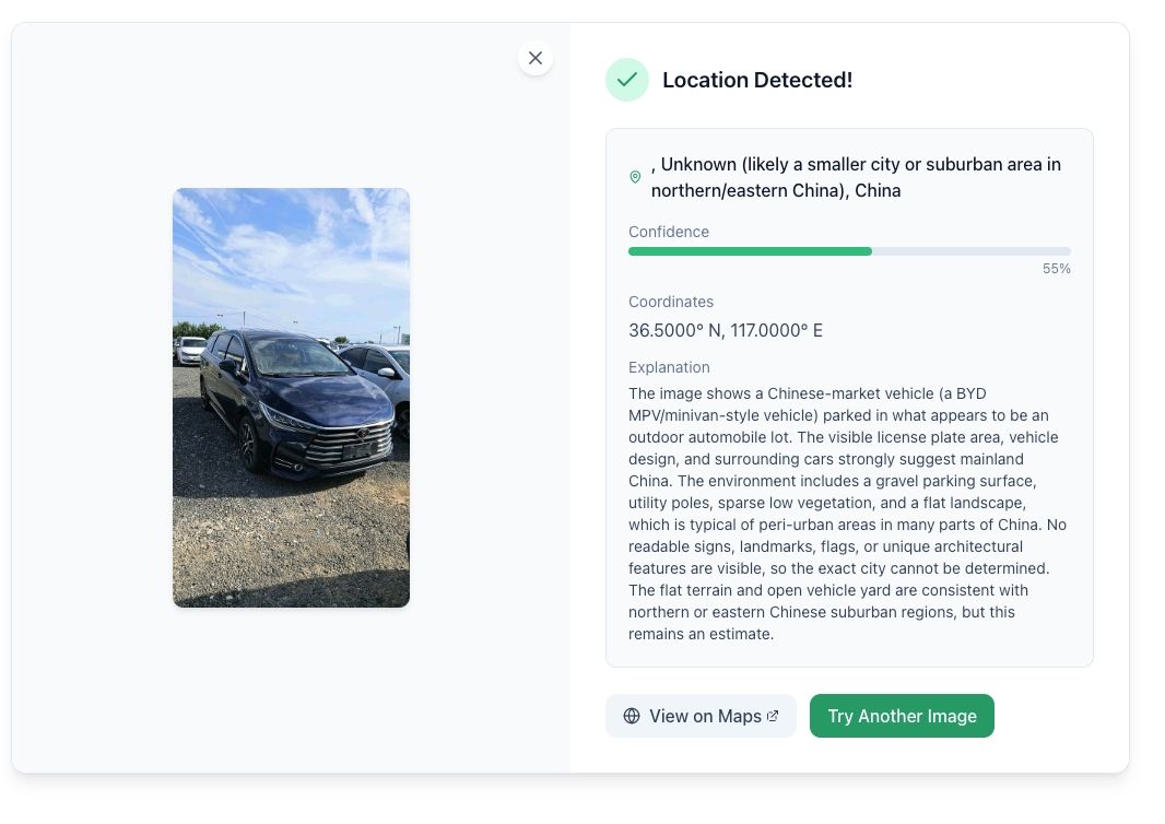
- Review the result: you get a map pin, estimated coordinates, predicted country and city, and a confidence level
- Check the reasoning breakdown to see what clues the AI identified
That's it. No account creation, no email signup, no payment. The tool is genuinely free — not "free for 3 searches then pay $29/month" free.
What kind of accuracy to expect
I'll be straight with you: accuracy varies a lot depending on the photo.
| Photo type | Typical accuracy | Example |
|---|---|---|
| Urban street scene with signage | City-level /often within 5km | Street in Lisbon with Portuguese signs |
| Distinctive landmark | Very high /near-exact | Sagrada Familia /Tokyo Tower |
| Rural landscape with terrain features | Country or region level | Mountain range with distinctive geology |
| Beach or generic natural scene | Country level at best | Tropical beach — could be Thailand or Mexico |
| Indoor photo | Very low — often unusable | Restaurant interior no windows |
| Close-up or macro | Near zero | Flower/food/object |
Any tool that claims 99% accuracy is not being honest. The best tools in ideal conditions hit the low-to-mid 90s. In tough conditions, they're educated guesses with a confidence score attached. Always treat the result as a strong lead, not a confirmed fact — especially if you're using it for something that matters.
Method 4: Manual visual geolocation (free, most effort)
When you need to verify a result, or the AI wasn't confident, or you just enjoy the puzzle — manual geolocation is how professional investigators and OSINT analysts do it. It takes longer but can reach remarkable precision when you know what to look for.
The process is systematic: you extract every geographic clue from the photo, then cross-reference each one against mapping tools until only one location survives.
The clue checklist
Text and language — Signs, billboards, storefronts, license plates. Language identifies the country. Business names can be searched directly. License plate formats vary by country and sometimes by state.
Architecture — Building materials, roof shapes, window styles. Red brick buildings with pitched roofs suggest Northern Europe or North America. Whitewashed stucco with flat roofs points to the Mediterranean. The relationship between buildings and the street also matters.
Infrastructure — Which side of the road do cars drive on? What color are the road markings? Are the traffic lights horizontal or vertical? What do the mailboxes look like? Manhole covers, streetlight designs, and fire hydrant styles all follow national standards.
Natural features — Terrain type (mountainous, coastal, flat). Vegetation species — palm trees mean tropical or subtropical, saguaro cacti mean the Sonoran Desert, baobab trees mean sub-Saharan Africa. Soil color varies by region — red laterite soil indicates tropical zones.
Shadows — If you know the date the photo was taken, shadow angles reveal approximate latitude. A tool like SunCalc.net lets you verify whether the shadow direction matches the AI's location prediction.
Verification tools (all free)
- Google Earth Pro — Satellite imagery, historical imagery, 3D terrain. The desktop version is free and far more powerful than the web version.
- Google Maps Street View — Ground-level reference photos. Drop the AI's predicted pin and check if the street view matches your photo.
- Mapillary / KartaView — Crowdsourced street-level photos covering areas Google hasn't reached.
- SunCalc.net — Sun position calculator for any date, time, and location.
Our manual geolocation walkthrough covers each signal category with real examples if you want to build this skill properly.
Which method should you use?
Here's a simple decision flow:
If the photo is from your own camera/phone → Check EXIF first (Method 1). Takes 5 seconds and gives exact coordinates if GPS data exists.
If it's a famous landmark → Start with reverse image search (Method 2). Google Lens will probably nail it instantly.
If it's a photo from the internet with no metadata → Use AI geolocation (Method 3). This covers the widest range of photos and handles screenshots, social media downloads, and forwarded images.
If you need verified, documented accuracy → Use AI to get a starting point, then verify manually (Method 4). This is what journalists and investigators do — AI narrows the search, human analysis confirms.
For 90% of people reading this, Method 3 is where you should start. It's free, takes under 10 seconds, and works on photos that no other free method can handle. Try it on GeoSpy — upload any image and see what the AI finds.
What about tools that claim to be free but aren't?
A quick warning, because the SERP is full of these. Many "free photo location finder" tools fall into one of these traps:
- Free but requires signup — Some tools let you search but gate the actual results behind account creation. You upload a photo, wait for analysis, then discover you need to register to see the answer.
- Free but watermarked or low-resolution results — The tool identifies a location but won't show you the map pin or coordinates without paying.
- Free EXIF readers that can't do visual analysis — These only work if your photo has GPS metadata, which most internet-sourced photos don't.
GeoSpy is the only tool I've found that's genuinely free with no signup wall, no daily limit, and no results gating. The tradeoff is that it doesn't offer the specialized features some paid tools have (multi-agent verification, batch processing, API access). For most personal use cases, that's a perfectly fine trade.
Can I identify location from a photo someone sent me on WhatsApp?
Is there a completely free way to find photo location?
How accurate is free AI photo location identification?
What's the fastest way to find a photo location?
Is it legal to find the location of someone else's photo?
Try GeoSpy for free now
The fastest way to see this work is to try it. Grab a photo you're curious about, upload it to GeoSpy, and read the prediction.